
Low water levels at Thirlmere Reservoir
The autumn of 2015 had been one of the best autumns I had ever seen in the Lake District with many dry and very still days. It was definitely very productive photography-wise.
In mid-October I was out walking near Legburthwaite in St. John’s in the Vale. A section of the walk was on the path running along Thirlmere Reservoir’s eastern shore. More often than not you have to stick to the path as one side is bounded by thick, impenetrable undergrowth and on the other is the lake. Not on this day though as I was able to take the following photo.
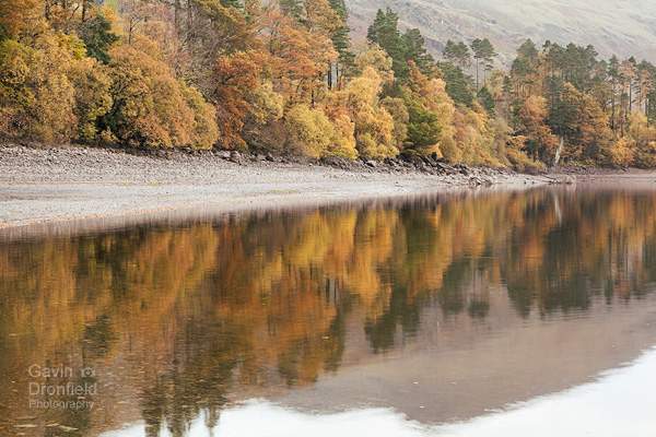
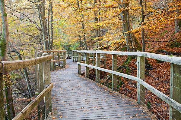
Autumnal Thirlmere shoreline
Thirlmere’s water levels had dropped by so much that the strip of pebbles forming the shoreline was much wider than normal. To take the above photo I was actually stood on a spit of land that jutted out into the lake.
I have heard tales of the water levels getting so low that the hamlets that used to occupy valleys before they were flooded become visible. Ok, the levels weren’t that low but this is about as low as I have seen the water in Thirlmere Reservoir. There was plenty of shoreline to walk on.
Not long after this was taken in November the driest Lake District autumn I can remember ended and water levels quickly returned to normal levels.
Storm Desmond Arrives
Roll the clock forward a few weeks and the first weekend in December 2015 was the first full weekend I had spent in Yorkshire in four years. That was pretty good luck on my part but obviously plenty of others in Cumbria weren’t so lucky. This was the weekend when Storm Desmond caused so much damage and disruption to the area.
Since November the weather has been pretty terrible in the Lake District but I wanted to see how things had changed so popped out the weekend after the storm hit northern Cumbria.
Even though the A591 Keswick to Ambleside road was closed due to landslides in the Thirlmere Valley I did manage to get to Legburthwaite and take a look at the reservoir. Ideally I would have liked a second photograph taken from the same location as the one above but that wasn’t going to happen as I didn’t have a boat to hand! Take it from me though: there is no shoreline visible now and the reservoir was about as full as it can be.
A lot of the permissive paths round the reservoir are closed too as they haven’t been safety checked yet by United Utilities. Evidence of small landslips can be seen everywhere though. With what I could do being so limited, it was time to move on.
Keswick to Threlkeld railway line from Threlkeld
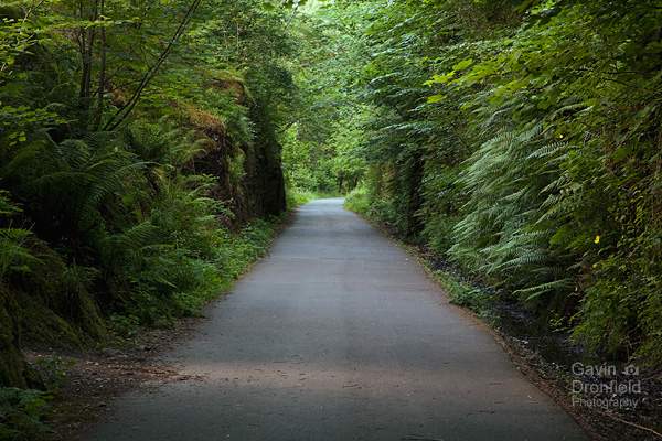
Next was a wander from Threlkeld, along the old railway track towards Keswick. This is a part of the National Cycle Network C2C Route and as such is very popular with both cyclists and walkers. I tend to use it on very bad weather days, purely to burn off some energy so it seemed a good time to walk along it as far as I could.
Picking up the course of the old railway line at Threlkeld Bridge, its obvious that something major has happened due to the material hanging from tree branches level with the footpath. At time of writing the still-swollen River Greta is a good ten feet lower than the path. It obviously wasn’t at some point though!
Further along the track the first of the old iron railway bridges across the River Greta had been cordoned off by the National Park Authority. Its still in one piece though so can be crossed – I’m guessing the warning is in place for heavier traffic or they want to undertake a safety inspection before opening it? Anyway I’m a law unto myself so stepped over the cordon and pressed on. At a later date I spoke to someone who worked for the National Park and was told that had I looked at the underside of the bridge I would have seen why it was cordoned off!
Further on, the second bridge is a different matter.
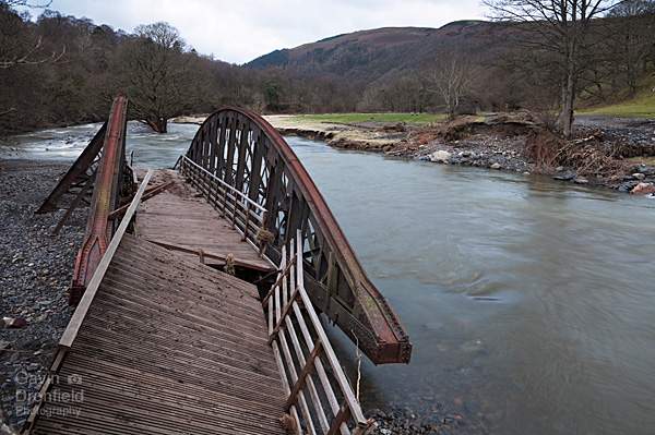
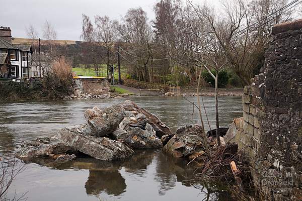
Damaged bridge over River Greta from south bank
Ok, this crossing of the River Greta wasn’t going to be easy! Credit to the original engineers though as the bridge is still in one piece, it’s the foundations on the far side that gave way as they were undercut by the raging torrent that the River Greta became during Storm Desmond.
Having had to retrace my steps and circle round via the hamlet of Wescoe I rejoined the course of the railway line on the other side of the bridge. It doesn’t look any better from this side though.
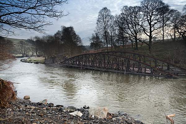
Damaged bridge over River Greta from north bank
After discussing how it could be fixed with members of a passing Threlkeld walking group we concluded it couldn’t and I was on my way further down the tracks. I didn’t have to go far to find the next obstacle though.
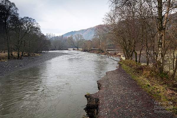
Collapsed path beside the River Greta
There is no bridge missing here. This is where the storm surge has undercut the bank on a bend in the River Greta to the point where the entire bank has collapsed taking the path with it. The resultant drop is at least ten feet. By clambering over a fence down to the right, into the field bordering the path this can be circumnavigated and the path picked up on the other side of the gap.
Sadly the next obstacle is impassable. There was a metal bridge similar to the one in the previous photograph passing back over the River Greta but this one has gone. Totally. The only signs of it are the brick foundations on opposing sides of the river but the bridge itself is nowhere to be seen. According to someone I had spoken to earlier on no one has found the bridge yet but I find it hard to believe that such a large cast iron bridge could have remained undiscovered for a week. These are strange times though …
If I remember rightly, there was also a small path that stuck to the same side of the river at this point too but, thanks to a large landslip, no sign of that remains either.
I realised it was time to give up.
Trying to look on the bright side (and it does take some effort!) there have been quite a few attempts by a local group to try to rebuild the Keswick to Threlkeld railway as a tourist attraction. They have been met with a mixed response but it is the Lake District National Park Authority that have the final say and to date they have always turned down the applications. This has been much to the appreciation of most cyclists and walkers (this author included). However had the plans been approved and the line rebuilt the cost of the repairs would be far greater than they already are. I suspect the people involved with trying to reinstate the railway will be breathing a big sigh of relief (insofar as anyone can be relieved at such damage).
As to how to fix the damage, obviously it is not the highest priority as people’s homes and the roads are much more important: there is sterling work going on on that front already. Sadly I fail to see what can be done with the old railway track though. Just putting the track back to how it was will be expensive enough but how long before the next storm hits and the same thing happens again? It would be such a shame to lose such a historic part of the Lake District, especially given how many people make use of it. If anyone does know the answer please forward your suggestions to the Lake District National Park Authority as I haven’t a clue!
In February 2016, after writing the above paragraph the National Park Authority released a statement estimating the amount of time it will take to repair the old railway line eighteen months to at two years. I think patience will be required!
In the meantime any proceeds I make from any print or stock sales this month (December 2015) will be donated to the “Cumbrian Flood Appeal 2015” (2017 Update: I have removed the Flood Appeal link that was here as the Cumbria Foundation have removed the relevant page from their site). Prints of any of my photographs can be purchased in my online shop and details of where photograph licences can be bought from are on my Contact Me page.
Keswick to Threlkeld railway line from Keswick
In January 2016, after first publishing this blog, a friend and I did a walk from the other end of the line to see how far it was possible to walk from that direction. Having parked in Keswick near the swimming pool we set off and didn’t get very far at all. The raised wooden walkway just outside Keswick has been closed off as the river bank on which it stands has been deemed unsafe. Ah well, never mind.
The walkway above the River Greta before Storm Desmond
Above is a photo of the walkway taken a few autumns ago. I’m not sure what state it is in now though as we were unable to get this far.
Pooley Bridge
Also in January 2016, I did a walk along the River Eamont from Pooley Bridge. The famous old stone bridge that gave the village its name has stood here at the northern end of Ullswater since 1764 but Storm Desmond has put an end to that.
Pooley Bridge post Storm Desmond
At the time of my visit a noisy generator was supplying the row of houses on the western side of the River Eamont with electricity and work was underway to put a temporary replacement in place before the summer season. Without it the village of Pooley Bridge is quite difficult to get to, especially considering both Eamont Bridge south of Penrith and Brougham Bridge are also closed.
January 2016: Donation to the Cumbrian Flood Appeal 2015
I have made a donation to the Cumbria Flood Appeal now of £50. Thanks to all those who paid for photo prints or licenses in December.
Reopening of the Keswick to Threlkeld Railway Trail
As a postscript to this article, the trail along the disused railway line was closed for 5 years while it was being worked on. In December 2020, five years to the month after Storm Desmond, the trail reopened. And very popular it is proving too and its nigh on impossible to have the p[lace to yourself during the day. However head there late on a weekday evening in summer and you might just be lucky.
The Keswick to Threlkeld Railway Trail in 2022
Further reading:
Subscribe to my newsletter
To receive an email whenever a new blog entry is published please enter your email address below and it will be added to my list:
Your email address will not be shared.